Showing posts with label Just for Fun. Show all posts

Friday, March 31, 2017

Picture of the Week

One project includes over 4.3 million pictures and
consumes more than 13 TB of disk space.
Michael Baker utilizes Orbit GT software to deliver Mobile LiDAR point cloud data and imagery to each of our clients. Our use of Orbit is highlighted in our As Seen on TV post from last September. Typically, one of the first steps in our processing workflow is to extract the spherical imagery and publish through our online portal.

We have numerous projects served up through our BEAST platform and encompasses tens of millions of pictures. These images provide a means for processing, data validation and visualization.

Orbit Publisher provides a framework for serving content to our clients without their requirement of having infrastructure to support Big Data.

The map image shows all of the collected routes in blue.  The images at right show 3 different panoramic images captured.

Cheers!
Stephen

Monday, October 24, 2016

Scrabble and LiDAR

Earlier this month I was on LinkedIn and read a posting on somebody’s page that LiDAR is now an official word in the Scrabble game’s dictionary. I guess that’s a good thing to know. For people that work with LiDAR or acquire the data from a service provider, you perhaps just got a slight edge over your board-game competitors. At least that’s true for those competitors that are not as LiDAR aware or informed as you.

In some respects, I’m still left at odds to think about “scrabble” and that word’s meaning in any context related to LiDAR. According to Merriam-Webster's Learner's Dictionary scrabble means to: “scrawl, scribble; to scratch, claw, or grope about clumsily or frantically; scramble, clamber; to struggle by or as if by scraping or scratching.” That’s sort of an incongruent meaning with the precise nature of the LiDAR systems we utilize and the projects we perform with Mobile, Aerial and Static LiDAR systems. Then again Scrabble is just a game and LiDAR is just a word of no particular importance in that game. Let’s move on.

What is important however, is that LiDAR is such a pervasive technology today that it’s become a common technology even to the layperson. LiDAR has far more usefulness in every day purposes than the mapping-grade systems we operate. LiDAR systems and their data are being deployed in ways that truly reaches the mainstream of our everyday lives. As we so well know, autonomous vehicles of all forms are being deployed with LiDAR capabilities for object detection and recognition and directional guidance.

So back to the subject of this blog, here is Michael Baker’s tribute to all those Scrabble players that will use “LiDAR” in their future games.
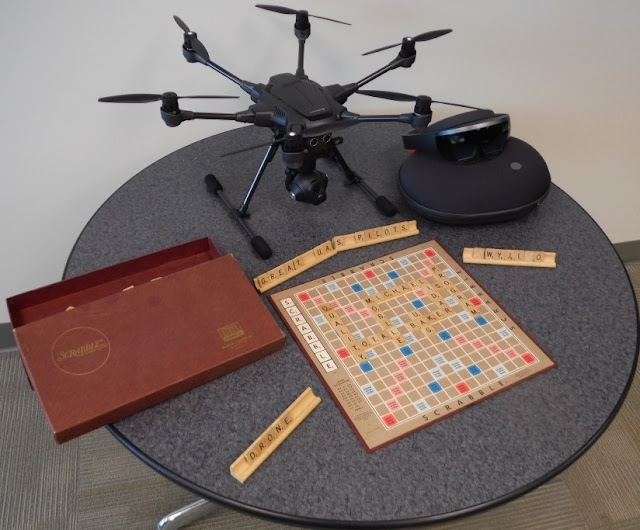


You’ll note that we’re also emphasizing some of the qualities on the game board that we feel are important to our LiDAR operations here at Michael Baker. We’re also displaying a HoloLens system and a UAS being on the table. The UAS is being evaluated by our Kevin Pomaski for potential future flight operations. We are already integrating Mobile LiDAR and panoramic imagery with UAS photography to create 3D data for immersive holograms using HoloLens.

With this in mind, it’s also my pleasure to re-introduce Kevin Pomaski to you. Kevin had worked at Michael Baker in the past and has rejoined us (a boomerang) to now provide his personal leadership to our UAS activities and the integration of converging technologies. We will continue to develop innovative solutions for project delivery. Kevin will soon be writing about some those amazing things he is doing while merging UAS data and Mobile LiDAR data, and creating HoloLens visualizations. Kevin will be adding his blog postings on these activities to this blog site in the coming weeks.

Finally, if you want some additional Scrabble tips for LiDAR, this is a pretty good site to learn what you can do with LiDAR in your next Scrabble competition: http://scrabble.merriam.com/finder/lidar.

Until, next time,
Bob Hanson

P.S.: Art Morris who leads IT support for our systems for LiDAR and UAS here at Michael Baker says those Scrabble tiles placed on the stand to the right have a very special meaning to “The Simpsons” fans.

Friday, May 1, 2015

Picture(s) of the Week

I was waiting to post this, but it's making the rounds on other social media sites and within Michael Baker International.  Also, there can't be a better day than our 75th Anniversary Celebration to show this off!

With the acquisition of another Mobile LiDAR system, we have deployed our combined approach to Mapping the Nation's Infrastructure.  The vehicle utilizes the Optech Lynx SG1 Mobile LiDAR system, Pavemetrics Laser Crack Measurement System (LCMS) and GSSI RoadScan Ground Penetrating Radar (GPR) systems for a combined approach.

Another modification includes the mounting of 3 of the Lynx 5-mega pixel cameras forward of the systems to capture forward facing frame imagery - while also deploying the Ladybug 5 spherical camera.

Cheers!
Stephen


Wednesday, March 11, 2015

We're on Instagram


The Mobile LiDAR team is now on Instagram! The crews are going to upload pictures to show off some of their travels.  The first few pictures (and a movie) are posted, but now that the wraps are completed and unveiled, there will be more forthcoming.

Cheers!
Stephen

PS:  Although I'm not pictured, I was on the boat... 


Thursday, July 18, 2013

Mobile LiDAR User Survey

Last week at the Esri International User Conference, I spoke to a lot of people about Mobile LiDAR.  There were a broad range of questions presented across disciplines.  From those questions, I have developed a list of future postings.

However, as I develop those posts, I have composed a brief survey in an attempt to tailor postings to topics of interest.  If you have a couple minutes, please provide feedback on important factors for your utilization of Mobile LiDAR.

Cheers!
Stephen


Create your free online surveys with SurveyMonkey , the world's leading questionnaire tool.

Friday, May 31, 2013

Picture of the Week

Earlier this month, Jackson, MS was supposed to play host to the Navy's Blue Angels at the 50th Anniversary Airshow. However, the show was cancelled due to sequestration cuts.  I was really looking forward to it as a good friend of mine is a local Navy recruiter and promised I could sit in the cockpit - I would play Maverick to his Goose.

Continuing with a Navy theme for the second week in a row, I submit our Pictures of the Week. Cue the Kenny Loggins music...

Posing with a retired Blue Angel.
A point cloud displayed by intensity values.
A point cloud colorized from on-board cameras.
Cheers!
Stephen

Friday, May 24, 2013

Picture of the Week

The picture of the week kicks off the Memorial Day weekend with a unique perspective of our men and women in uniform.  Often people in our scans are moving, which causes distorted profiles when viewing data collected from both sensors.  These sailors were standing patiently, waiting to enter the mess hall.  It's easy to see which sailors were standing motionless.


Have a safe and enjoyable Memorial Day!

Cheers!
Stephen

Tuesday, January 15, 2013

Safety and Record of Survey

While I have started drafting new posts to start the new year, nothing is complete to date.  However, this is too important a topic to discuss to delay posting.  My esteemed colleague Aaron Morris pointed me to an online story that speaks directly to the topics of safety and record of survey.  We take every precaution to successfully and safely complete a collection.  Baker operates our Mobile LiDAR vehicle with two persons - one dedicated to driving, while the other concentrates on the data collection.  There are numerous road obstacles that warrant a driver's undivided attention, particularly when an expensive piece of equipment is mounted to the roof.  Therefore, the operator is also responsible for assisting with navigation and hazard detection when it is warranted.

As data is collected - both LiDAR and imagery - detailed survey information is recorded. The data is georeferenced and time-stamped.  It is simple to retrace the field activities to determine application of best practices; that necessary routes were/are collected; the information meets the scope of work and other conditions.  We review vehicle trajectory, raw LiDAR data, or photography to validate the information and communicate results.  We do place close attention to operating speeds with respect to posted speed limits and the environment being collected. These are some of the measures we employ to ensure a culture of safety, achieve safety ratings, and mitigate any potential liability.

Typically, however, we do not publish our information freely on the web.  Should we elect to do so, I believe the precautions we take would eliminate confusion and stories such as this:  Story

After a quick search, we learned that you drive on the left-hand side of the road in Botswana.  Perhaps that wasn't taken into consideration by the reporter.  You decide.

Friday, October 12, 2012

Picture of the Week

The image I posted two weeks ago created some good natured discussion regarding allegiances.  As Baker is based in Pennsylvania, I work with a lot of people who do not share my rabid devotion to a certain SEC University.  In order to appease my colleagues to the north, I quickly pulled together some publicly available Aerial LiDAR data and imagery.  Below is a colorized point cloud of the PSU campus. With the PAMAP program, there are great datasets available.


Have a good weekend.

Cheers!
Stephen

Wednesday, October 10, 2012

Top 3 Posts

If you're relatively new to Baker's Mobile LiDAR blog, you may not know that it's something we've been doing for about three years now.  In that time, there have been a few that have hands down attracted more attention than others.  Perhaps the reasoning is that older posts have had more time to attract pageviews.  However, our number one viewed blog was written nearly a full year after number 2 and 3.

#1:  Modeling Bridges from Mobile LiDAR Information
In this posting written in October 2010, I illustrate how three-dimensional modeling and rendering is performed from information collected for an interstate corridor.  The mapping was completed by Baker's Applied Technologies Group using MicroStation.

#2:  To Debunk or Not To Debunk - That is the Question
One of our earliest postings was derived from one of our first collections - performed just 4 days after the installation of our system.  We were in central PA attending a corporate meeting.  While checking into our hotel, we noticed the rack of brochures for area attractions.  One was for Gravity Hill - a local attraction where: "Cars roll uphill and water flows the wrong way. It's a place where gravity has gone haywire."  We collected the hill, but the data resides on a hard drive on my shelf left unprocessed while the mystery remains unconfirmed.

Again, another posting from 2009 earns a top spot.  As our blog was taking shape, it was important to talk about the equipment and how it performs.  In this posting, I discuss the positioning systems on the vehicle:  GPS, IMU and DMI.  It has gained a lot of attention as did a similar article written for LiDAR News titled:  Mobile Positioning Systems.   

I hope you have the time to review some of our earlier postings.  I like to revisit things we've done in the past just to see how far we've come.

Cheers!
Stephen

Wednesday, March 21, 2012

Like us on Facebook

Some time ago, I created a Facebook page for our operation - an informal place to share photos and other materials in addition to the blog.  Late one evening last week, I applied the new Timeline view to the page and created a URL.  As the days, weeks, months and years pass by, it becomes increasingly more difficult to remember our history.  Hopefully this helps.


I've tasked our crew with providing additional content as they journey about the country. If you're so inclined, Like us on Facebook.

Cheers!
Stephen

Thursday, June 30, 2011

Baker's Dozen: 13 Laws of Mobile LiDAR

A little over a month ago, our Ridgeland office hosted a visit by Baker's CEO, Brad Mallory.  During a presentation of projects our Transportation group was working on throughout Mississippi, it was quickly observed that several of the slides had 13 projects listed - a Baker's dozen.

From that meeting, an idea was born to develop "Baker's Dozen: 13 Laws of Mobile LiDAR."  These Laws were developed after much thought and consideration.  In coming posts, I will explain each of the Laws in detail providing further explanation.  

Without further ado, I unveil the Baker's Dozen: 13 Laws of Mobile LiDAR (also currently being chiseled on a slab of granite):
  1. Too much is better than not enough.
  2. Sometimes more is just more, not better.
  3. Hard drives are cheap, time isn’t.
  4. Consistency counts; stop guessing.
  5. When someone wants “full planimetrics,” they really don’t.
  6. The stated laser range is X’, but the lasers are only capturing data to Y’; and Y is definitely less than X, yet nobody can tell you what Y is…
  7. The data you capture is only as good as the applied control.
  8. Today’s best practices will be tomorrow’s old habits.
  9. Field vs. office time ratios are pipe dreams.
  10. Mobile LiDAR systems are not created equal, and neither are the operations behind them.
  11. Off-the-shelf processing software will only do 50% of what you need it to do.
  12. When the system encounters issues, take a breath and reboot.
  13. Mobile LiDAR is not all fun and games, but it does feel like it some days.  

Feel free to let me know what you think.  Perhaps we can have a committee gathered to debate them or formalize some agreement.

Cheers!
Stephen

Friday, February 4, 2011

Lots of Dots

The other day, a friend and business acquaintance addressed a letter to me as "Mr. Lots of Dots."  I thought it was fitting given that my professional life is all about dots, dots that we measure and dots showing where we've been.

That evening as I was reading my son his favorite story - There's a Map on My Lap* - the words took on a entirely new meaning.  Even though I've probably read the book 200 times, one particular rhyme stood out:

"Dot maps, like this one,
are covered with dots.
Some have a few dots,
but some others have lots."


Last week, our Mobile LiDAR vehicle surpassed 40,000 miles (several more miles if you include it taking a ride on a barge).  With each new mobilization as we're collecting more dots, we're also adding new dots for the places we've been.  If it wasn't for the wrap we have on the truck, I would have one of those sticker maps you see on the back of RV's because,

"You can always use maps.
They will help you in knowing
where you have been 
and just where...
...you are going."


If you are a geospatial professional and have children (or a wife that doesn't understand what it is you really do), the book There's a Map on My Lap is a great way of explaining what you do. I've bought copies for several friends that have become new parents. Also, it makes a great read for younger students for GIS Day.


Enjoy!
Stephen

*References to: There's a Map on My Lap! By: Tish Rabe; Dr. Suess Enterprises, LP Copyright 2002

Monday, August 9, 2010

How Well Did You Do?

Following up on the Name That Car Contest, I've compiled the cars that were depicted in the point clouds. Craig is the winner with 4 correct.  Some of these proved a little more difficult than others and for good reason.  Thanks to all of you who participated - even submitting into Friday morning. I've attached some of the images.  

#1: Ford Escape - multiple people identifying it as a Mazda Tribute (same car).  I had the luxury of a photo of the front - the blue oval is unmistakable.


#2: Acura MDX

#3: Honda Accord - Going old school with the old body style.

#4: Audi A3 - The front grill gives it away.

#5: Ford Econoline:  No body missed this one.

#6: VW Beetle:  Again, no body missed this one.


#7: Chevrolet Aveo: The one nobody got.


Something that threw me regarding #7 is how the plastic bumpers appear different than the metal body in the point cloud due to the various intensities.


Wednesday, July 28, 2010

Reminder to Enter the Contest

Don't forget to enter the Name that Car Contest.  There is one week left before the entries are reviewed and the winner determined. I can not possibly put into words how great these Baker travel mugs are. Don't miss out!

Monday, July 26, 2010

Gotta Love Intensities

While compiling images for the "Name that Car Contest", I created a few more interesting screen captures of vehicles.  What they're delivering may be a question if it weren't for the intensity values from the LiDAR data. Each of these images were derived from a single pass of our vehicle down the streets of Morgantown, WV.

I hope you find this as interesting as I do...


Wednesday, July 21, 2010

Name That Car Contest

A colleague sent me a few screen shots this morning of vehicles we captured during a collection.  After looking at them, I went back and looked at information from another collection.  I thought it would be fun to make a little contest out of the vehicles in our scans.  Each of the cars below were captured during collections while they were either stopped at lights or parallel parked.

Rules of the contest:  Send me an email with the number above the vehicle along with make and model.  The first person that correctly identifies all seven vehicles wins a Baker travel mug, as pictured.  I will verify vehicles using pictures captured during our collection and manufacturer websites.  The contest closes on Wednesday, August 4th at 5 pm central.  If nobody gets them all right, the person with the most, wins. Baker employees are not eligible to win, but submit guesses anyway. The contest is not open to individuals outside the United States - nothing against you, but it would require a trip to the post office. I will post the name of the winner and notify them via email. I have the right to cancel the contest at any point if you don't play nice!

#1

#2

#3

#4

#5

#6

#7


Enjoy the contest, please leave comments and feedback.  Entries to the blog are dictated by you, the reader.

Thanks,
Stephen

Tuesday, May 4, 2010

The Size of Data - Zettabyte?

I spent a few hours this past weekend helping my wife clean out our home office.  In all the clutter, she found a case for 3.5" floppy disks containing about 50 disks. While we perused the labels on the disk - HP Printer Driver Disk 1 of 3, GIS Topics (senior elective), endless blanks - we searched the house for a computer with a disk drive capable of determining the need to keep any of them.  Of the 3 computers in our home, we came up empty handed.  


After chatting a bit about the need to keep things we didn't even know existed in the first place, my wife relented and I threw them in the garbage.  Then I promptly removed them from the garbage. As my wife brought to my attention, the same person who's going to rummage through garbage to find personal information, probably has a drive that somebody else threw away. So, as I began destroying the disks, I contemplated the size of the data they contained.  After all, it's interesting to see how technology, and storage, has developed over the past years or decades.


Over the past 20 years, we've witnessed the size of data and what we store grow to astronomical levels - levels that even require the invention of new words.  From kilobytes, megabytes, gigabytes, terabytes, petabytes, exabytes to zettabytes - One zettabyte is equal to one million petabytes, or 1,000,000,000,000,000,000,000 individual bytes. (The yotabyte is next.)


To give you an idea of the amount of data we capture with the system, I've compiled a table presenting rates given the camera and laser frequencies:

Measurement Frequencies
50 kHz
100 kHz
200 kHz
Camera Rates

Cameras Off
3 MB per second
6 MB per second
12 MB per second
1 frame per second
13 MB per second
16 MB per second
22 MB per second
2 frames per second
23 MB per second
26 MB per second
32 MB per second
3 frames per second
33 MB per second
36 MB per second
42 MB per second

Looking at these numbers, it would take about 0.034 seconds to fill up one of those disks I threw away - when the system is working at peak performance. Our operators would need fast hands and a steady supply to keep up with the system. Thankfully, we have a constant supply of hard drives to transfer information from the vehicle to our processing facilities. 


With the advancements in computer processors, memory, video drivers and software, we have come a long way with what we're able to effectively manage.  The slide show prepared for Baker's 70th Anniversary provided me a glimpse of where we've been...  


I can't imagine processing Mobile LiDAR data with that computer - although it cost significantly more than the systems we use today.

Happy 70th Baker!  Here's to another 70!

Wednesday, April 7, 2010

It's Official: 3D is the New Standard

Growing up, I felt I was more fortunate than my brother when it came to not having to wear glasses (especially those hideous Army BC glasses).  Today when discussing glasses, I'm not talking in terms of optical power, but rather Anaglyph versus Polarized.

Movies and TV
Chances are you have likely seen a movie in 3D.  With the proliferation of Avatar and movies from Pixar there is a growing awareness and desire for 3D.  At 2, my son sat through Ice Age: Dawn of the Dinosaurs with his polarized glasses on the entire time.  Even now, if you have $2,500+ you can purchase a 3D DLP or LED television (3DTV).  There are announcements constantly about the progression of 3D channels to supply content to these devices.


The Internet
You may not have noticed a recent change to Google StreetView. To be honest, it took me by a little bit of a surprise. Below is a screen capture of the I-110 interchange I've discussed in this blog before.  Notice the new icon.  There have been many times where I have shown our Mobile LiDAR collection of this interchange in 3D using anaglyph glasses.


Mobile LiDAR
We have been presenting 3D animations and renderings of our Mobile LiDAR collections for quite some time.  (Below is the same expanse of the I-110 interchange as shown in the new StreetView.) Looking at 2D images does not provide a measure of depth that is afforded with this information.


Revisiting the Mississippi River Levee collection, I've created an image that can be viewed in 3D using anaglyph glasses.


I now wear glasses - not because of a loss of vision, but to gain perspective. 

If you would like a pair of anaglyph glasses to view the blog, send me your address and I'll mail you a pair.

Thursday, March 11, 2010

Clouds - Not the Fluffy Kind

Following up on the "Question of the Day" post, I wanted to share a video that was produced of the I-110 collection in Baton Rouge.  The video was part of a presentation given earlier this week at the National States Geographic Information Council Mid-Year Conference in Annapolis, Maryland.

The collection consisted of 27 different approaches to the interchange and took about one and a half hours.  The dense collection of points is commonly referred to as a Point Cloud - Wikipedia has a limited definition.  The cloud shown in the video is composed of 491 million points.