Monday, November 14, 2011

Data Fusion: Mobile and Aerial LiDAR

Over the weekend, Baker's latest article on LiDAR News was published.  The topic is "Data Fusion" - Mobile and Aerial LiDAR as well as traditional surveying.  In an earlier posting on the blog, I wrote about Knowing your Limitations - whether they're environmental, scale or technological.  Often, one tool or technology does not completely solve a problem.  By fusing data from multiple sources, we're able to complete the picture. 

Below are the images from the article in more detail:

The image above presents the fusion of Aerial LiDAR (red) and Mobile LiDAR (white). The tops of structures, including poles and push braces, are completely saturated with LiDAR points while the rail corridor (immediately adjacent to the buildings) contains dense information.

The image above depicts the fusion of Mobile LiDAR and Traditional Surveying (Aerial LiDAR points removed for clarity). The LiDAR data was supplemented outside of the Mobile LiDAR corridor to locate utilities, property boundaries and other features not captured by Aerial means within the larger corridor.

As the closing states, the information represented in surveying/engineering drawings can be captured in a number of ways.  Having an array of tools at your disposal can dramatically impact how you approach an assignment.  The integration of outputs from various technologies can provide a different perspective.

Cheers!
Stephen

Wednesday, September 21, 2011

Mobile LiDAR: Law #13

Mobile LiDAR is not all fun and games, but it does feel like it some days.

What could be more enjoyable than mounting a couple lasers on top of a 4 wheel drive SUV, cruising at highway speeds, shooting it at everything that the eye can see and calling it work? It’s a career that would have Tim “The Toolman” Taylor stand-up and say “more power, ARGH, ARGH, ARGH”, (although our system is manufactured by Optech, not Binford). How about adapting it to fit a boat, an all-terrain vehicle or a hi-rail? Now we’re talking… it’s like a sophisticated NextGen video game that would make my twelve year old son envious. In this context, it’s easy to forget that the laser is a highly advanced optical imaging system, operated by experienced survey technicians, which is used to collect vast amounts of precision data for a multitude of real world applications. If engineered correctly, a Mobile LiDAR unit will serve as a cost-effective survey grade solution that can be used to generate high quality project deliverables in a surprisingly quick timeframe. This is where the fun stops and the real work starts.
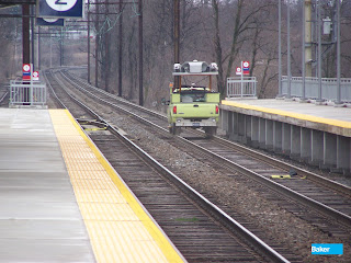
Baker's Mobile LiDAR unit is mounted on a Hi-Rail equipped truck
to perform a collection on a railroad corridor.

The implementation of a mobile LiDAR project can often be a rigorous undertaking, sometimes involving hurdles that would challenge the greatest of the world's Olympic sprinters. First and foremost is the sale. You would think that the system’s efficiency, accuracy and safety features would enable the technology to sell itself, but the resistance to change innate in economic buyers sometimes results in the need for the “hard sell”.

There’s hardware and software configuration, system calibration, survey control, and pre and post processing procedures that must be painstakingly followed to ensure a quality data output. And let’s not forget the logistics of scheduling… Mother Nature is not always the most forgiving of patrons. Mobile LiDAR data collections are serious business. However, if managed properly, it might just give four wheeling on a muddy summer day in the bayou a proverbial run for its money in the fun and games category.

Got LiDAR?

Cheers!
David

David Fekete is GIT Operations Manager for our Harrisburg, PA office.  He joins other manager's within Baker's GIT Service Area as a guest author to the blog.  In the coming weeks, additional guest authors will continue providing content from a different perspective.

Monday, September 12, 2011

Mobile LiDAR: Law #8

Today’s best practices will be tomorrow’s old habits.

We hear a lot about “Best Practices;” but first off, let me say that I’m not a fan. Context, culture, and regulations dictate our practices. What equals success in one market may not work in another. And not all locations are created equal. So, for most purposes the terms, “good practices”, “suitable practices” or “useful practices” make more sense to me.

So what makes a good/suitable/useful practice…a so-called best practice? Since bottom-line is critical in business, any best practice must be measurable and must contribute to the bottom line. If a practice isn’t cost effective, it isn’t going to happen. Systems must support change in practice, and processes must allow for interaction between the users and the implementers.

Being a relatively new technology, change in Mobile LiDAR is rapid. So while the technology is cutting edge, the processes for developing our LiDAR projects ought to be our old habits. Today, they represent good/suitable/useful practices…the so-called best practice.
  • Plan, Plan, Plan – You’ve heard about GIGO: Garbage in Garbage out. It’s as true in Mobile LiDAR as in any other project type. To avoid GIGO, getting ready for the project is as important as the actual work that follows. (See Project Planning - GPS post)  Identify all state and other relevant agency specifications and project coordinate systems. Develop a mission plan for data collection. Perform system calibration, reconnoiter geodetic control for SBET processing and establish necessary survey control necessary post processing of LiDAR data. 
  • Get the Data – Set up base stations on geodetic control.  Collect the GPS and Mobile LiDAR data . Perform preliminary data processing, including data extractions and SBET creation; and finally, generate the point-cloud. 
  • Process Data – Transform, tile and classify point data. Produce intensity images. Make various extractions. 
  • Develop the Product(s) – Digital Elevation Models (DEM's), Triangulated Irregular Networks (TIN's), contours, breaklines and detailed planimetrics. Generate tile and project level-set metadata. 
  • QA/QC – Don’t treat QA/QC as a final step. Incorporate it in every instance. 

You’ll definitely get the best product with these best practices.

Cheers!
Donna

Donna Kristaponis is GIT Operations Manager for our Reno, NV office. She and other managers within Baker's GIT Service Area will be providing guest postings over the coming weeks.

Thursday, September 1, 2011

Re-purposing the Cloud

Sustainability is a hot topic these days. The high-density point-cloud generated from a single Mobile LiDAR collection is a virtual poster-child for sustainable solutions. A key advantage to utilizing Mobile LiDAR on most projects is the ability to re-purpose the data for a myriad of uses or downstream projects. Rarely, if ever, do we get the opportunity to fully capitalize on the wealth of captured information on a single project. But if you’re an organization with diverse needs or numerous departmental groups, such as a local municipality, the ability to re-purpose the point-cloud for multiple projects creates exponential cost savings each time the data is exploited.

Land Development is another great example. We recently deployed our system to capture the as-built condition of a business and technology center in Chesapeake, VA. The center is relatively new, so there are still a number of vacant parcels that have yet to be developed. Scanning the entire complex took about an hour; but from that single collection, the developers not only obtain an accurate as-built of the site, but can also re-use the data to:

  • Develop land-use classification models;
  • Create animated fly through’s or 3D renderings to entice prospective tenants;
  • Quickly assemble to-scale 3D architectural renderings for the design/review process; or
  • Analyze and assess the enforcement of local codes/ordinances relating to sight-lines or green space.

The fascinating part is these were just the first things that came to mind. I think our motto sums it up pretty well. Unlimited Data…Infinite Possibilities!

Cheers!
Jonathan

Jonathan Soulen is GIT Operations Manager for our Virginia Beach, VA office.  He and other managers within Baker's GIT Service Area will be providing guest postings over the coming weeks.  

Friday, August 12, 2011

SAE 2011 Autonomous Vehicle Symposium


Baker’s resident LiDAR Scientist, Dr. Srinivasan “Srini” Dharmapuri,  was a featured presenter at the Society of Automotive Engineers (SAE) 2011 Autonomous Vehicle Symposium, held at Carnegie Mellon University (Pittsburgh, PA) on 8/10/11. The symposium showcased smaller and more focused discussions on innovative drive assist and autonomous vehicle technologies in transportation, agriculture resource management, construction and mining.  Srini’s presentation conveyed the advantages and uses of Mobile LiDAR technology, and  highlighted several case studies performed by Baker in the Transportation arena , including roadway design, rail transit, and bridges.  The diverse group of international attendees included prominent individuals from the public and private sectors, as well as academia.

As Baker's resident LiDAR Scientist, Dr. Srini is responsible for application development, QA/QC methodologies, technical writing, improving processing efficiency and other related LiDAR (static, mobile and aerial) activities. As mentioned in an earlier posting, Srini is the Vice Chair of the ASPRS Mobile Mapping Committee.  Perhaps he can provide an update on the committee's activities in the near future.

 If you have a topic for Srini to write about, please leave it as a comment and we'll include it the Ask the Doctor series.

Cheers!
Stephen

Thursday, July 28, 2011

Mobile LiDAR Interview with Aaron Morris

During the 2011 ESRI International User Conference, Baker's Aaron Morris took a few moments away from our booth to be interviewed by VerySpatial.  Aaron provides a background on Mobile LiDAR and highlights some of our recent projects.  The podcast is now available online or through iTunes.


Thank you to Jesse and the rest of the crew at VerySpatial for the opportunity for us to share Mobile LiDAR with their listeners.

Cheers!
Stephen

Friday, July 22, 2011

Mobile LiDAR: Positioning Systems

In my most recent article for LiDAR News, I provide an overview of Positioning Systems for Mobile LiDAR.  It is a little more in depth than a blog posting I prepared back in 2009 titled Measuring Systems Part 1 - Positioning.

Mobile LiDAR is a system comprised of various components that are connected to provide a solution.

My belief is that the Position and Orientation System (POS) used to develop the Smoothed Best Estimate of Trajectory (SBET) is the distinguishing factor between available Mobile LiDAR systems. The ability to accurately position the vehicle has downstream advantages for the initial LiDAR processing and subsequent control adjustment.

Cheers!
Stephen

Saturday, July 16, 2011

Mobile LiDAR Blog goes Mobile

Following up on the recent redesign to the blog, I  applied a mobile template so it can easily be viewed on your smart phone or other mobile device.  Since it seems we're all on the go these days, it will be easier to check in to see the latest postings.

Sample of the Mobile Template

In addition, I've included the QR code that will take you directly to the site.  After having a Blackberry for nearly a decade, I'm still getting used to my iPhone keyboard and the code comes in handy.
Let me know what you think of the recent changes.

Cheers!
Stephen

Thursday, June 30, 2011

Baker's Dozen: 13 Laws of Mobile LiDAR

A little over a month ago, our Ridgeland office hosted a visit by Baker's CEO, Brad Mallory.  During a presentation of projects our Transportation group was working on throughout Mississippi, it was quickly observed that several of the slides had 13 projects listed - a Baker's dozen.

From that meeting, an idea was born to develop "Baker's Dozen: 13 Laws of Mobile LiDAR."  These Laws were developed after much thought and consideration.  In coming posts, I will explain each of the Laws in detail providing further explanation.  

Without further ado, I unveil the Baker's Dozen: 13 Laws of Mobile LiDAR (also currently being chiseled on a slab of granite):
  1. Too much is better than not enough.
  2. Sometimes more is just more, not better.
  3. Hard drives are cheap, time isn’t.
  4. Consistency counts; stop guessing.
  5. When someone wants “full planimetrics,” they really don’t.
  6. The stated laser range is X’, but the lasers are only capturing data to Y’; and Y is definitely less than X, yet nobody can tell you what Y is…
  7. The data you capture is only as good as the applied control.
  8. Today’s best practices will be tomorrow’s old habits.
  9. Field vs. office time ratios are pipe dreams.
  10. Mobile LiDAR systems are not created equal, and neither are the operations behind them.
  11. Off-the-shelf processing software will only do 50% of what you need it to do.
  12. When the system encounters issues, take a breath and reboot.
  13. Mobile LiDAR is not all fun and games, but it does feel like it some days.  

Feel free to let me know what you think.  Perhaps we can have a committee gathered to debate them or formalize some agreement.

Cheers!
Stephen

Monday, June 27, 2011

Riding the Rails

Back in March, Baker performed a Mobile LiDAR collection of a high speed rail corridor encompassing approximately 240 miles (opposing tracks along the same corridor).  Now that the primary products have been delivered, I took an opportunity to create several screen captures of the collection.  The two images below present different views of the same section of track.

Facing northwesterly, the screen capture clearly depicts the ability to capture a number of elements beyond the rail features.  The handiwork of local "artists" is evident thanks to the intensity returns from the system.

An opposite view from the image above shows the extent of overhead electric distribution, communication and fiber optic  utilities.  Also present are supporting guy anchors, a single mile post and other features necessary to develop engineering design drawings.
The detail of information captured in a single collection is quite impressive.  In addition to the planimetric feature extractions and track geometries, Baker developed a digital elevation model following constraint of the Mobile LiDAR collection.

Let me know what you think.
Stephen

Wednesday, June 15, 2011

Complexities of a Mobile LiDAR Survey

A few weeks ago, my fifth article for LiDAR News was published.  The article, titled "Complexities of an Urban Survey," discussed our recent collection of Charleston, WV.  The collection encompassed an incredibly varied urban and rural environment along 350 miles of public rights of way (collected in opposing directions).  Through project planning, we attempted to mitigate or minimize the known challenges we were going to face.  

The images presented in the article are shown below:

As the article states, we established control target layout for a local survey firm.  Above is a representation of a Google Earth KMZ depicting the control point layout.

Each SBET (sometimes a few a day due to weather) were exported to a Google Earth KMZ to perform cursory review of status.

Our Mobile LiDAR crew and Program Manager, Aaron Morris, provided an "Open House" to city staff and the media.
My next article for LiDAR News will be on the Position and Orientation System.  Should you have a topic to consider, leave me a comment.

Cheers!

Stephen

Friday, May 6, 2011

ASPRS - Mobile Mapping Committee

The ASPRS Mobile Mapping committee meeting took place on May 2nd at ASPRS's Annual Conference held in Milwaukee, Wisconsin.  Dr. Craig Glennie from the University of Houston, Texas is the new Chair and  Dr. Srini Dharmapuri, LiDAR Scientist at Baker is the Vice Chair.
The meeting began with a discussion of the some of the significant activities in the mobile mapping community over the last year, including:
  • The release of mobile laser scanning specifications by Caltrans
  • The currently pending TRB contract to develop guidelines for mobile LiDAR in transportation applications
  • The formation of the GTMA (Geospatial Transportation Mapping Association)
After this brief summary, it was decided that the committee should concentrate on the formation of a best practices and guidelines document, with the goal of having an initial draft prepared for ASPRS 2012.  To this end, a proposed framework for this document was presented (and given in the attached word file). 


The Mobile Mapping committee is looking for volunteers to assemble “best practices document” and interested parties may get in touch with Dr. Craig Glennie and Dr.Srini Dharmapuri. 


Good luck to Craig and Srini as they lead the endeavor to establish standards and best practices for the Mobile Mapping industry.


Click to download the Mobile Mapping Committee Presentation.


Cheers!
Stephen

Thursday, April 21, 2011

No Place for Survey Crews

Earlier this year, we were tasked to perform a Mobile LiDAR collection of an Interstate tunnel (2 lanes in each direction - measuring 0.8 miles in length).  The tunnel is in a heavily trafficked urban corridor where closures required by traditional surveying, even in the early morning hours, were completely out of the question.

Due to the constant, unrelenting traffic, we performed the collection shortly after midnight.  We collected each of the 4 travel lanes at or slightly below posted speed limits - slowing down or speeding up to minimize laser shadows from other vehicles.  Following the collection, our LiDAR processing staff and Applied Technology Group produced the final products.

First, our LiDAR processing staff adjusted the passes to ensure coincidence.  Then they made quick work of removing other vehicles from the point cloud.  Then, they turned over the tiled point clouds for modeling.

An image of the point cloud with vehicles removed, but tractor trailer model added.  Notice the pothole in the bottom left hand corner of the image. 

Our Applied Technology Group utilized the cleaned point cloud to create a rendering of the tunnel in MicroStation.
In the article I wrote for LiDAR News last week I made the statement "if you can’t see it, the system isn’t measuring it." The below image is directly disputing that statement - which I don't quite mind in this case.  

The image shows a cross-section of the tunnel.  Notice the arc above the "box" tunnel.  The arc represents returns from the actual tunnel ceiling (extent of bore) that were measured through small (1") joints in the false ceiling.
Perhaps what is most fascinating to me is not that the system captured this information, but how it will be exploited by our client.

Cheers!
Stephen

Monday, April 18, 2011

Knowing your Limitations

I have recently prepared another article for LiDAR News titled Knowing your Limitations.  Understanding what a technology does not do is equally, if not more, important than understanding what it does do.  Where those limitations can affect the successful outcome of a project, other methods, tools or techniques are needed to compensate.  The article addresses some of the larger topics.  In upcoming posts, I'll provide additional items to consider when pursuing a Mobile LiDAR project.

The images presented in the article are shown below with captions:

Manholes:  In a span of 40' along a roadway, there are 6 manholes and two water valves.

Grass on Bare-Earth/DEM:  A random non-Federal levee shows the difficulty dense vegetation adds to determine bare earth along the bank.

Obscured Areas:  The area behind two parallel parked cars is obscured in comparison to the open area between them.  The shape of the voids depicted, represents the orientation of the lasers and varies based upon heading.
As always, please let me know if there are any topics you would like to see discussed.

Cheers!
Stephen

Friday, March 4, 2011

Defining Accuracies

I have written a third article for LiDAR News  which addresses accuracies of Mobile LiDAR information.  It may be accessed through this link.  

The images in the article illustrate how we constrain our collections to ground control, much in the same was as aerotriangulation (AT) in Photogrammetry.

The table shown below (and included in the article) illustrates the difference between our check points (labeled Control) and the LiDAR point elevation at the corresponding locations.  This methodology is used to calculate the accuracy per the National Standards for Spatial Data Accuracy.


Should you have a topic for discussion, please leave as a comment.

Thanks,
Stephen

Friday, February 4, 2011

Lots of Dots

The other day, a friend and business acquaintance addressed a letter to me as "Mr. Lots of Dots."  I thought it was fitting given that my professional life is all about dots, dots that we measure and dots showing where we've been.

That evening as I was reading my son his favorite story - There's a Map on My Lap* - the words took on a entirely new meaning.  Even though I've probably read the book 200 times, one particular rhyme stood out:

"Dot maps, like this one,
are covered with dots.
Some have a few dots,
but some others have lots."


Last week, our Mobile LiDAR vehicle surpassed 40,000 miles (several more miles if you include it taking a ride on a barge).  With each new mobilization as we're collecting more dots, we're also adding new dots for the places we've been.  If it wasn't for the wrap we have on the truck, I would have one of those sticker maps you see on the back of RV's because,

"You can always use maps.
They will help you in knowing
where you have been 
and just where...
...you are going."


If you are a geospatial professional and have children (or a wife that doesn't understand what it is you really do), the book There's a Map on My Lap is a great way of explaining what you do. I've bought copies for several friends that have become new parents. Also, it makes a great read for younger students for GIS Day.


Enjoy!
Stephen

*References to: There's a Map on My Lap! By: Tish Rabe; Dr. Suess Enterprises, LP Copyright 2002

Thursday, February 3, 2011

Mobile LiDAR: Projects at a Glance

My second article for LiDAR News is now available.  It may be accessed through this link.  

The image in the article is shown below.  It is an intersection of SR30A in Panama City, FL - collected May 2010.  You can clearly make out the extraction of pavement markings, sidewalks, utilities, pavement edges and other features.


Should you have a topic for discussion, please leave as a comment.

Thanks,
Stephen

Wednesday, January 26, 2011

Dick Henderson Animation

I uploaded an animation of our Dick Henderson Bridge collection to YouTube some time ago.  The short video shows the combination of the point cloud information with derived planimetrics of the underneath structure and piers.


I compiled the animation using Pointools with a little transition editing afterwards.  I've been using the software for some time now to generate these animations and to create the screen captures shown in this blog.

Cheers!
Stephen

Monday, January 24, 2011

Corridor Mapping

Recently we were awarded a contract to perform mapping along a 108 mile corridor through central Louisiana.  Our Mobile LiDAR crew completed the data collection over two days - each day collecting 2 passes in opposing directions.  In order to illustrate the ground covered, I exported the vehicle trajectory to a Google Earth KML file (see below).


Along the corridor, there were several areas where the alignment was uncertain.  Due to the ease of acquiring additional areas, our crew made additional passes to completely capture the necessary information.  The image below demonstrates how our crew made multiple passes along the new US 167 alignment as well as the old alignment.


The Size of Data:

Covering all that ground is bound to create a substantial amount of data.  During the collection, our system acquired 55,727 images.  In addition, we processed 170.3 GB of LAS files.

My colleagues and I are contemplating how many points were collected over that time period.  Would anybody venture a guess?  Feel free to post your guess!  Should I get a number of guesses, I may post the actual number.

Cheers!
Stephen

Wednesday, January 12, 2011

Mobile LiDAR & GIS: Background of a Service Provider

I have the pleasure of being a contributing author to LiDAR News - a new electronic newsletter by Spatial Media.  My specific focus will be Mobile LiDAR and GIS - with a host of other contributers addressing Aerial LiDAR, Static Scanning and Processing.

My first article is now available and is a basic introduction of things to come.  It may be accessed through this link.  I will be collaborating with other authors when appropriate to address processing, animation and sensor fusion.

Should you have a topic for discussion, please leave as a comment.

Thanks.