Thursday, July 28, 2016

Throw Back Thursday

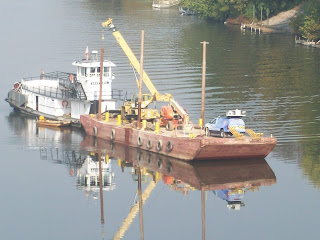
For our first "Throw Back Thursday" post, we go all the way back to 2010 with the Dick Henderson Bridge project in St. Albans, WV.  It was our first Mobile LiDAR collection from the water.

Our client already had a barge on-site to support inspection and other activities.  Therefore, we were able to simply drive the vehicle onto the barge and collect the underside of the bridge in a matter of a couple hours.  Using painted survey targets on the bridge, we seamlessly merged the data from the barge with data collected on the bridge.  In a previous post titled "West Virginia - Preliminary Information", the trajectories from the two collections are presented.


The data was utilized to help develop design alternatives for public consumption.  They can be viewed on the West Virginia Department of Transportation website.  Furthermore, the information aided in the development of a demolition plan, including a controlled blast.

As mentioned in Tuesday's post, it is rewarding to see the completed projects.  The bridge officially reopened in October 2013, as covered by the Charleston Gazette Mail.

Cheers!
Stephen
Tuesday, July 26, 2016

Picture of the Week

My friends and coworkers know that when I travel with my family, I prefer to drive rather than fly.  It’s not that my wife doesn’t know how to pack/dress to go through security smoothly.  It’s because I love to see new places and stop at roadside attractions.  We ultimately endeavor to visit all 50 states together.

A trip last week to Traverse City, MI for the MAPPS Summer conference afforded the opportunity to put more miles on the family car.  While I don’t necessarily route our trajectory through past Mobile LiDAR projects, we almost always hit one or two along the way.  Although many of the projects have long been collected, processed and delivered, the remnants (targets) are still visible – every 500’ – 1,000’.  

The white chevron target of a past Michael Baker Mobile LiDAR project is visible in the shoulder. 
The spacing of Mobile LiDAR targets makes them easy to spot - add a painted number and the marking's purpose is undeniable.  The most rewarding part is not the evidence of targets, but new travel lanes, resurfaced road or other infrastructure improvements which were the basis of our work.

Cheers!
Stephen

Friday, July 8, 2016

Pictures of the Week

Recently, we had the pleasure of performing a unique elevated rail collection.  To capture the rail corridor, our system was installed on the clients' Hi-Rail equipped Kubota side-by-side.


The Kubota provided an ideal platform to perform the collection.  The beautiful, clear blue skies yielded exceptional photographs - which were delivered in an online Orbit publication.


Above, the operator monitors the collection, examining real-time imagery, point cloud data and positional metrics. The driver had it easy with no traffic or steering to contend with.

Cheers!
Stephen

Monday, July 4, 2016

Happy Independence Day!

As we celebrate our nation’s independence this Fourth of July, we encourage you to reflect on the diversity of peoples, beliefs, cultures, traditions, and histories that have come together to make this great country. Enjoy your time with friends and family and have a safe and responsible Fourth!

The Mobile LiDAR Team