 |
Copyright, Hanna Barbera and Warner
Bros. Entertainment, Inc. All Rights Reserved. |
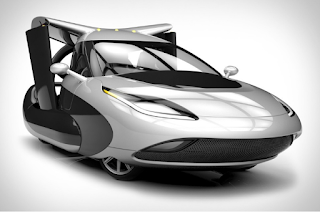
As a kid I was introduced to the concept of flying vehicles (cars) from watching The Jetsons. My adolescent imagination ran wild with thoughts of the freedom found in such flight. While I did not know the definition of an autonomous vehicle at the time, the picture here apparently shows a limited controlled and largely autonomous family vehicle. Autonomous machines and vehicles are abuzz in our technology thinking today. Many visionaries have imagined flying cars. Some have actually produced results. The future of flying cars is much closer than you may be aware. On June 21st of 2016, the FAA approved a new petition (it was not the first for the company) for an exemption to Terrafugia’s vehicle “…allowing a vehicle in the Transition® street-legal airplane configuration to be certified as a Light Sport Aircraft (LSA) with a maximum takeoff weight of 1,800 pounds. This is a significant increase over the allowance received in 2010 which granted the Transition® a 1,430 pound weight limit, the same as currently imposed on amphibious LSA.”
To see the video of this Terrafugia vehicle in flight use this link:
https://www.terrafugia.com/the-transition/ or
https://www.terrafugia.com/
How does this sort of technology relate to Michael Baker? When our company entered the Mobile LiDAR market seven years ago, we spent a lot of time here at our company discussing, amongst our LiDAR team and clients, the real issues we encounter with occlusion of LiDAR from either the ground (mobile) or from an airplane (aerial). In either scenario, line of sight limitations won’t let us see the top of things from the ground, under things from very high in the air, or through things in either case. If only I could attach wings to our Mobile LiDAR vehicles! If only I could economically put a commercial LiDAR system on a vehicle like that envisioned by Terrafugia! Such a vehicle of course has to be engineered to configure its wings and propellers to consider the placement of LiDAR
and camera systems. But, I’m a bit ahead of the point I want to make with any emerging, converging technologies.
While I patiently wait for a more visionary and technologically feasible solution for deploying high density, engineering-quality mobile LiDAR systems that can fly as well as be driven, I can now turn with some hope to Part 107 of the FAA’s implementation of commercial small unmanned aerial systems (sUAS) for interim possibilities. Keep in mind, at the top of my list of the impediments to complete success with any LiDAR approach is occlusion. Getting full 360 degree coverage of an object or area of interest is especially challenging with Mobile LiDAR projects, since some sites are inaccessible with driving. Roof tops on flat buildings are a practical impossibility. From the air, we can potentially collect data with sUAS using imagery and small LiDAR systems to fill those occlusion areas and data voids resulting from line of sight limitations with Mobile LiDAR systems. With sUAS we can fly low, hover and fly in a very controlled way to fill voids in Mobile LiDAR data. Temporal updates for specific areas of interest (e.g., change) can also be performed cost effectively with sUAS against an existing point cloud previously acquired with LiDAR.
As a long term FAA Section 333 exemption holder for commercial sUAS operations, Michael Baker can now look at the certain less restrictive conditions and the possibilities and opportunities created in Part 107 (
https://www.faa.gov/news/press_releases/news_story.cfm?newsId=20515).
Two areas that catch one’s imagination are:
- No operations from a moving aircraft.
- No operations from a moving vehicle unless the operation is over a sparsely populated area.
For the first of these, I am sure there is a reason why somebody might or could want to fly a sUAS from another flying aircraft, perhaps attempting to fly and operate a sUAS while also flying in a hot air balloon comes to mind for some purpose (expanded line of sight).
I now know I can’t fly a sUAS from the Terrafugia TF-X. That fact might keep me from soon placing my order for one of those flying cars. I need to think through the impact of the sUAS limitation with my desired TF-X. But, the Terrafugia TF-X is so cool, anyway! I have to categorize this FAA limitation as a minor annoyance not to be able to fly my sUAS from the TF-X.
I still want to imagine a Mobile and Aerial LiDAR system on that TF-X flying car.
For the second FAA case of allowing operation of a sUAS from a moving vehicle, I think there are some possibilities for this application with Mobile LiDAR. This sort of flight operation must occur under the correct and safe circumstances. The FAA will apparently allow us to operate a sUAS from a moving vehicle under the right, approved scenarios and with an added exemption issued by the FAA and for specific area(s). This sort of exemption can be applied to rail lines and perhaps controlled roadways. I can’t yet imagine all the possibilities for us, yet. But, the marriage of integrated Mobile LiDAR and sUAS will happen very quickly here at our company. Soon our Mobile LiDAR systems will roll out on nearly all projects with their sUAS(es) as part of their compliment of equipment for survey control, imagery and LiDAR. Getting the remote Pilot – Small Unmanned Aircraft Systems Airman Certification comes next.
I’ll have more insights on that process later.
Cheers!
Bob
Robert Hanson is Senior Vice President and Michael Baker's National Practice Lead for Geospatial Information Technologies. Bob is known as a visionary and futurist within our ranks and was the driving force for Michael Baker's acquisition of our first Mobile LiDAR system in 2009.


