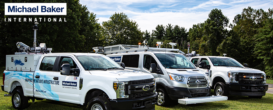
 Pittsburgh, PA – Optech and Michael Baker International are pleased to announce that they have signed an agreement for the delivery of two new Lynx SG1 Mobile Mapper™ Systems, the latest model of Optech’s industry-leading line of Mobile LiDAR solutions. The purchase completes an upgrade for Michael Baker International’s existing Lynx system to the SG1 specification, equipping the firm with two of the most powerful mobile mapping systems in the world. The first of the new Lynx SG1 systems is scheduled for immediate delivery to Michael Baker International.
The latest in Optech’s line of mobile mappers, the Lynx SG1 collects ultra-dense 3D data with survey-grade accuracy from a vehicle travelling at cruising speeds, along with co-aligned camera imagery. With Optech’s Lynx SG1 systems, Michael Baker International will remain at the forefront of the engineering profession and will expand its national business by efficiently accomplishing high accuracy engineering surveys and asset mapping for managing highways, runways and other
infrastructure. Michael Baker International will also utilize the technology in support of MAP-21 program objectives for the Department of Transportation by using Mobile LiDAR systems to gather data necessary to achieve highway performance goals for safety, infrastructure condition, and sustainability.
“We are excited to enhance and expand our core capabilities with the new Lynx SG1 Mobile Mapper™ systems,” said Robert Hanson, Michael Baker International’s National Practice Lead – Geospatial Information Technologies (GIT). “We were amongst the first innovators in the use of Optech mobile mapping technology with our system acquired five years ago. The high quality Mobile LiDAR work that is produced by our in-house team of experts has earned a strong reputation. Our registered quality programs have achieved ISO 9001:2008 – ANSI/ISO/ASQ Q9001-2008 certificates for both Design and Provision of Professional Engineering and Consulting Services for Mobile LiDAR Field Collection, and for LiDAR Data Processing. At Michael Baker International, we understand the engineer’s needs and a project’s demands, so we are able to make a big difference in our clients’ expectations for the products and services we deliver.”
“The Optech Lynx has been powering Michael Baker International’s mobile mapping and surveying endeavors for some time now, and we are happy to expand their capabilities with the latest model of Lynx,” said Albert Iavarone, Business Unit Manager at Optech. “We are very happy that after examining the various options available to them, Michael Baker International once again decided that the Lynx SG1 was the best fit for their demanding projects. Optech is committed to ensuring that our clients get the best possible value out of their investment, which is why we are also modifying their existing Lynx system to the SG1 model. This upgrade will keep their existing surveying tools at the forefront of the industry for some time to come.”
About Michael Baker International
Michael Baker International, LLC is a leading global provider of engineering and consulting services which includes planning, architectural, environmental, construction, program management, and full life cycle support services as well as information technology and communications services and solutions. Baker provides its comprehensive range of services and solutions in support of U.S. federal, state, and municipal governments, foreign allied governments, and a wide range of commercial clients. With over $1 billion in annual revenue, Michael Baker International has more than 5,000 employees in over 90 offices located across the U.S. and internationally, and is ranked as the 26th largest design firm in the U.S. by McGraw Hill’s Engineering News-Record. To learn more about Michael Baker International visit: www.mbakerintl.com
About Optech
Optech is the world leader in high-accuracy LiDAR 3D survey systems, integrated cameras, and productivity-enhancing workflows. With operations and staff worldwide, Optech offers both standalone and fully integrated LiDAR and camera solutions in airborne mapping, airborne LiDAR bathymetry, mobile mapping, terrestrial laser scanning, mine cavity monitoring, and industrial process control, as well as space-proven sensors. Accuracy and productivity matter!


