Earlier this month I was on LinkedIn and read a posting on somebody’s page that LiDAR is now an official word in the Scrabble game’s dictionary. I guess that’s a good thing to know. For people that work with LiDAR or acquire the data from a service provider, you perhaps just got a slight edge over your board-game competitors. At least that’s true for those competitors that are not as LiDAR aware or informed as you.
In some respects, I’m still left at odds to think about “scrabble” and that word’s meaning in any context related to LiDAR. According to Merriam-Webster's Learner's Dictionary scrabble means to: “scrawl, scribble; to scratch, claw, or grope about clumsily or frantically; scramble, clamber; to struggle by or as if by scraping or scratching.” That’s sort of an incongruent meaning with the precise nature of the LiDAR systems we utilize and the projects we perform with Mobile, Aerial and Static LiDAR systems. Then again Scrabble is just a game and LiDAR is just a word of no particular importance in that game. Let’s move on.
What is important however, is that LiDAR is such a pervasive technology today that it’s become a common technology even to the layperson. LiDAR has far more usefulness in every day purposes than the mapping-grade systems we operate. LiDAR systems and their data are being deployed in ways that truly reaches the mainstream of our everyday lives. As we so well know, autonomous vehicles of all forms are being deployed with LiDAR capabilities for object detection and recognition and directional guidance.
So back to the subject of this blog, here is Michael Baker’s tribute to all those Scrabble players that will use “LiDAR” in their future games.
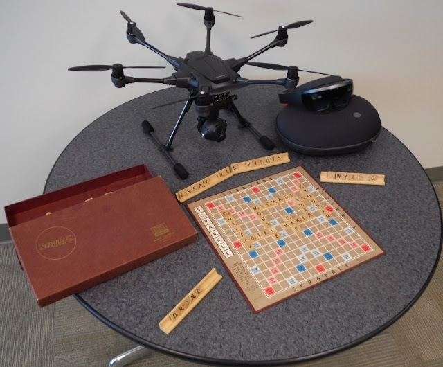
You’ll note that we’re also emphasizing some of the qualities on the game board that we feel are important to our LiDAR operations here at Michael Baker. We’re also displaying a HoloLens system and a UAS being on the table. The UAS is being evaluated by our Kevin Pomaski for potential future flight operations. We are already integrating Mobile LiDAR and panoramic imagery with UAS photography to create 3D data for immersive holograms using HoloLens.
With this in mind, it’s also my pleasure to re-introduce Kevin Pomaski to you. Kevin had worked at Michael Baker in the past and has rejoined us (a boomerang) to now provide his personal leadership to our UAS activities and the integration of converging technologies. We will continue to develop innovative solutions for project delivery. Kevin will soon be writing about some those amazing things he is doing while merging UAS data and Mobile LiDAR data, and creating HoloLens visualizations. Kevin will be adding his blog postings on these activities to this blog site in the coming weeks.
Finally, if you want some additional Scrabble tips for LiDAR, this is a pretty good site to learn what you can do with LiDAR in your next Scrabble competition: http://scrabble.merriam.com/finder/lidar.
Until, next time,
Bob Hanson
P.S.: Art Morris who leads IT support for our systems for LiDAR and UAS here at Michael Baker says those Scrabble tiles placed on the stand to the right have a very special meaning to “The Simpsons” fans.
Mobile LiDAR systems employ vehicle-mounted lasers, cameras and GPS/INS navigation systems to capture highly detailed 1:1 scale, 3D topographic data for surveying and engineering applications. Michael Baker International became an early adopter of Mobile LiDAR technology in 2009, and expanded our capacity in 2014 and 2015 to increase our fleet to four Optech Lynx SG1 Mobile LiDAR systems. Ask about custom solutions for utilities, rail, transportation, airports, pavement, photologs, and more.
Monday, October 24, 2016
Scrabble and LiDAR
Thursday, October 20, 2016
By the Numbers: Mobile LiDAR Processing
- 18: Number different software packages we use to collect and process Mobile LiDAR data.
- 1,000: Number of concurrent users that can access our LiDAR web-portal running Orbit Publisher. Michael Baker’s state-of-the-art portal enables clients to interact with their LiDAR, imagery, and planimetric data without the need of expanding their own enterprise architecture.
- 3: Number of primary LiDAR/LCMS processing centers in the U.S.: Hamilton, NJ; Pittsburgh, PA; and Jackson, MS.
- 90+: Number of domestic Michael Baker International offices our fleet of Mobile LiDAR systems supports.
- 10: Number of computers one LiDAR Technician can simultaneously operate to process data.
- 5: Number of Terabytes that can be transferred to our LiDAR Centers each day.
- 100+: Number of external hard drives in rotation between our fleet of 4 Mobile LiDAR systems and various processing centers.
- 50-200: Local capacity in available Terabytes at each of our LiDAR processing centers. The local storage is only used for short-term needs. Enterprise data storage processing is handled by our own private cloud (see Belly of the BEAST) which can handle up to 1 Petabyte of data.
Friday, October 14, 2016
Cultivating Excellence: Mobile LiDAR Operator Training
Success is not given for us, it is earned. For all of my team members in the LiDAR Center our success begins through the deployment of one or more of our Mobile LiDAR vehicles. Training new Mobile LiDAR operators is the most important aspect of the LiDAR Center’s daily successes. We have a saying within the LiDAR Center: “Our operators are the ones that actually drive our business.”
Our driver/operators are the tip of the spear for all of our Mobile LiDAR projects. With our increased work load, hiring and training operators has been paramount in recent months. These vehicles carry the LiDAR systems that create vast amounts of data. Effective field operations are the base of our entire operation. Without quality data every second of every day, a ripple effect is made all the way down the project’s product line.
Training begins typically on the new hire’s first day, with a multitude of training manuals, power points, and videos. Safety is our first priority in all our training. As Senior Operator, my job is to ensure our new hires know how to be safe while performing their work and flawlessly conduct every aspect of our collection tasks with our systems. All of this must be learned before they get in a Mobile LiDAR vehicle. It will take weeks to fully break down all of the necessary information presented to them. As we like to say, “It’s more than just pushing a button and driving.” Learning takes time and attention to all details. With daily experience they gain tremendous proficiency.
All aspects of our Lynx SG-1 system are introduced to them, from basic start up and operation, to troubleshooting and diagnosis. They learn how to adjust and calibrate the system, modify existing set ups to accommodate different equipment requirements, calculate scale factor, GNSS Azimuth Measurement Subsystem (GAMS) solution, etc. all in a short period of time. (If you wish to learn more about GAMS read an article written for LiDAR Magazine by our Stephen Clancy that may help you better understand the concepts and techniques for deriving positions from the equipment and software associated with Mobile LiDAR systems.)
Training will continue even after new operators have gleaned all they can out of their training manuals. Being in a Mobile LiDAR truck and performing a collection is an entirely different animal than being in a classroom. Weather, traffic, and unforeseen circumstances (such as other’s accidents/construction) can all play an integral role on a collection’s actual performance. It is the operator’s responsibility to not only determine the collection route within the designated collection area, but plan and assess all other extenuating circumstances that may impact the project’s requirements. The operator must be mindful of state and local laws, Michael Baker’s own safety rules and guidelines and staying within the designated project’s required accuracy and information specifications. Once a new operator has a few successful collections under his or her belt, they are fully integrated with collection planning, extraction and post processing of data including Continuously Operating Reference Station (CORS) data retrieval among other processing demands.
A Mobile LiDAR operator’s training is never fully complete. After two years of field experience I still find myself learning something new to share with others on our team each and every day. With constantly updated software, new, dynamic projects and the evolving LiDAR technology we adapt to such demands to keep abreast with application of this technology. Our work produces exciting new challenges every day. We will continue to meet and exceed our client’s expectations with exemplary collection practices and high quality data. With the proper training, order of operations, superior support staff and our senior leadership our operators will continue to excel both in and out of the trucks.
Cheers,
Jack
Jack King is Senior Mobile LiDAR Operator with Michael Baker International's Mobile LiDAR Center of Excellence. He has racked up more miles and projects than any other operator and can error handle with the best attitude and composure imaginable!
Subscribe to:
Posts (Atom)