Consistency counts; stop guessing.
 |
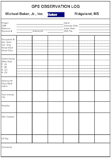
| Sample GPS Observation Log utilized by Baker |
Perhaps the 4th law of the Baker's Dozen was inspired by my early years in the surveying profession. I spent vast amounts of time collecting and processing static GPS for developing project specific and county-wide geodetic control networks. At each monument, we were required to record detailed information on a GPS observation log sheet. These sheets were utilized in post processing to validate antenna heights (recorded in feet and meters as further validation), input station number, and identify possible obstructions. An incorrect antenna height was usually the primary suspect in a bad baseline solution. I quickly became a fan of fixed-height tripods. Although at that time they were clumsy and didn't collapse, they minimized or eliminated Scribner's errors and second guessing.
Similar opportunities for inconsistencies to present themselves exist with Mobile LiDAR collection. We employ various methods and procedures to ensure successful collection - outlined in Law #7 - Applied Control. Our crew regularly deploys static GPS base(s) for SBET post-processing. For consistency, we utilize two meter fixed height tripods and record base information on a GPS log sheet. However, due to the complexity of a collection and equipment utilized, there are additional areas where consistency matters.
System Start-up and Collection
The successful start-up and operation of our Mobile LiDAR unit requires a process - it's not as simple as pushing a button and collecting LiDAR data. Our crew follows a carefully scripted procedure to start, setup, and perform a collection. From time-to-time our equipment manufacturer also provides updates to these procedures in the form of Customer Advisories. These steps must be followed to identify the root cause of a problem should one occur - see Law #12. Similar to the observation log, we capture information relevant to the collection to ensure all areas are covered. The information includes tire pressure, ambient temperature, weather conditions, and other factors - much like a traditional survey crew.
By taking copious notes, we have a record of field activities and conditions. We are consistent with the way our crew functions, which removes any guessing.
Cheers!
Stephen

No comments:
Post a Comment