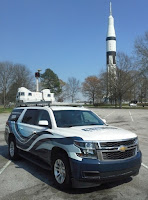
 It’s been a while since our last posting, and we’ve certainly appreciated your patience during this brief hiatus – but rest assured, plenty of new content (and contributors) is on the way. The expansion of our Fleet –4 Mobile LiDAR systems, plus an integrated Laser Crack Measurement System (LCMS), plus an integrated Ground Penetrating Radar (GPR), plus multiple static LiDAR units – temporarily diverted our attention from our social media content while we focused on scaling other areas of the operation to handle the workload simultaneously coming from four systems. Luckily our faithful followers have been treated to a regular stream of content to Instagram thanks to our new Fleet Manager.
Quadrupling your collection capacity in less than 8 months looks like a pretty straight forward process on paper, but launching a fleet of the most sophisticated mobile mapping systems at times felt like we were choreographing logistics for NASA’s Mission Control. Four times the number of collection systems means four times the amount of logistics, maintenance, personnel, proposals, storage capacity, and last but not least…Data!
It’s no small feat effectively handle up to 4 Terabytes of new data each and every day. Any way you slice it, that’s a lot of data. So there’s your parting thought for the day – How would you transfer 4 TBs of data from various locations throughout North America on a daily basis?
Cheers!
Aaron
LiDAR Services Director


No comments:
Post a Comment