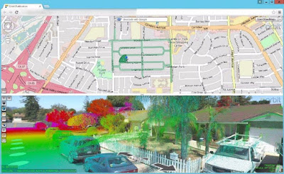
Now that you’ve got Gigabytes or Terabytes of processed Mobile LiDAR data, what do you do with it? Experienced end-users may have multiple tools to view and manipulate Mobile LiDAR data; but what about the average John Q. Public that doesn’t have tens-of-thousands of dollars to dump into software and training? To help our clients maximize their resources we’ve implemented a web-based solution on our BEAST environment (see Belly of the BEAST) that leverages the Orbit GT framework to link panoramic imagery, GIS/CAD features, and LiDAR point clouds into a single integrated solution that can be accessed from any of the most popular internet browsers.
By publishing the LiDAR data with Orbit end users are provided a user-friendly platform to view, collect, and interact with various forms of field-collected data. The configurable user environment typically contains two imbedded, user-scalable windows for an overview map (top section) and the panoramic imagery and LiDAR point cloud (bottom section). The overview map supports OpenStreetMap, which provides an excellent backdrop for the overlay of panoramic image locations and available GIS data. Similarly, GIS data can also be overlain on panoramic imagery / point cloud window(s), provided valid elevations are available in the GIS.
Other basemap functionality includes the ability to geocode addresses using Google’s geocoding engine, search by GIS object, and search by X,Y coordinates. The Search by Object tool is particularly helpful as it will search all attributes within the selected layer, not just on a single column.
The panoramic imagery / point cloud section also has a robust selection of tools through which the user can toggle on/off layers and interrogate GIS data, as well as the ability to open multiple viewing windows to simultaneously observe the same location from various perspectives. 360-degree pan/zoom functionality is standard, as are measurement tools including: positional location, distance, line (single and multi-segment), area, and volumetric calculations.
The beauty of the solution is the ease of use. Anyone that’s ever used an online map will be self-navigating and making meaningful observations within minutes – and all without any special software or any required training.
Stay tuned, I’ll share more content in the future about this and other technology being leveraged by our clients.
Regards,
Scott
Scott Peterson is a Systems Supervisor in Michael Baker's Ridgeland, MS office. His responsibilities include Database Administration for the BEAST, data maintenance and publishing for use by Michael Baker's staff and clients.


No comments:
Post a Comment